 |
Narrative of Mount St. Helens
 A
Slumbering Volcanic Giant As seen in the pre-eruption
photograph above, Mount St. Helens was once one of the most beautiful mountains in the
entire Cascade range in the American Northwest. In 1805, William Clark in the Lewis and
Clark expedition described Mount St. Helens as "perhaps the greatest pinnacle in
America." Photo: Dept. of
Natural Resources, State of Washington. Courtesy of NGDC/NOAA. A
Slumbering Volcanic Giant As seen in the pre-eruption
photograph above, Mount St. Helens was once one of the most beautiful mountains in the
entire Cascade range in the American Northwest. In 1805, William Clark in the Lewis and
Clark expedition described Mount St. Helens as "perhaps the greatest pinnacle in
America." Photo: Dept. of
Natural Resources, State of Washington. Courtesy of NGDC/NOAA.
 However, the serenity of the mountain
and its surroundings was misleading. One of the Indian names for Mount St. Helens was
"fire mountain," and local Indians were reluctant to approach the mountain
despite the abundant game in the area. To the experienced observer, the conical shape and
composition of rocks on the mountain boldly proclaimed Mount St. Helens' true nature--it
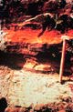
was a volcano. Lava flows and multiple layers of ash (powdered volcanic rock) lay
everywhere under the carpet of trees--abundant evidence of numerous prior eruptions.
Volcanic deposits had literally reshaped the entire region around the mountain. Even
beautiful Spirit Lake was a volcanic accident, created by a giant mudflow that rolled down
the mountain about 3000 years ago and backed up a stream. Photo:
University of Colorado. Courtesy of NGDC/NOAA. However, the serenity of the mountain
and its surroundings was misleading. One of the Indian names for Mount St. Helens was
"fire mountain," and local Indians were reluctant to approach the mountain
despite the abundant game in the area. To the experienced observer, the conical shape and
composition of rocks on the mountain boldly proclaimed Mount St. Helens' true nature--it
was a volcano. Lava flows and multiple layers of ash (powdered volcanic rock) lay
everywhere under the carpet of trees--abundant evidence of numerous prior eruptions.
Volcanic deposits had literally reshaped the entire region around the mountain. Even
beautiful Spirit Lake was a volcanic accident, created by a giant mudflow that rolled down
the mountain about 3000 years ago and backed up a stream. Photo:
University of Colorado. Courtesy of NGDC/NOAA.
Mount St. Helens was even intermittently active between 1832 and 1857,
during the early stages of settlement of the area by Easterners. But the eruptions were
small, and the mountain then "dozed off" for the next century. During this nap,
small settlements became towns and towns became metropolitan centers like Portland and
Seattle. These new neighbors of Mount St. Helens knew only the mountain in repose, and its
violent past was largely ignored.
 The Awakening The quiet ended rather abruptly in March 1980, with a series of steam explosions
and bursts of ash. The following narrative of events associated with the eruption of Mount
St. Helens is provided to illustrate the potential dangers of an eruption from Mount
Rainier. Photo: Dept. of Natural
Resources, State of Washington. Courtesy of NGDC/NOAA. The Awakening The quiet ended rather abruptly in March 1980, with a series of steam explosions
and bursts of ash. The following narrative of events associated with the eruption of Mount
St. Helens is provided to illustrate the potential dangers of an eruption from Mount
Rainier. Photo: Dept. of Natural
Resources, State of Washington. Courtesy of NGDC/NOAA.
 During the months following the
initial outbursts, volcanologists and seismologists watched the mountain closely. Small
earthquakes accompanied the bursts and indicated the intrusion of fresh lava into the
heart of the mountain. Enormous cracks appeared in the summit and sides of the mountain,
and the entire northern face expanded outward some 450 feet. All of this initial activity
was perceived by non-scientists as minor, so in spite of warnings and the designation of
the mountain and its surroundings as a dangerous "Red Zone," tourists flocked to
the area and evaded the overworked rangers to get a close view of the fireworks. Residents
of the area were strongly advised to move away, but some refused to go. Likewise, some of
the logging companies working in the area refused to shut down, claiming to "know the
mountain." Volcanologists established several camps around the mountain to monitor
its activity. To provide the necessary data, some of the camps had to be dangerously close
to the mountain. The volcanologists who manned the camps in shifts knew their own peril. Photo: Dept. of Natural Resources, State of
Washington. Courtesy of NGDC/NOAA. During the months following the
initial outbursts, volcanologists and seismologists watched the mountain closely. Small
earthquakes accompanied the bursts and indicated the intrusion of fresh lava into the
heart of the mountain. Enormous cracks appeared in the summit and sides of the mountain,
and the entire northern face expanded outward some 450 feet. All of this initial activity
was perceived by non-scientists as minor, so in spite of warnings and the designation of
the mountain and its surroundings as a dangerous "Red Zone," tourists flocked to
the area and evaded the overworked rangers to get a close view of the fireworks. Residents
of the area were strongly advised to move away, but some refused to go. Likewise, some of
the logging companies working in the area refused to shut down, claiming to "know the
mountain." Volcanologists established several camps around the mountain to monitor
its activity. To provide the necessary data, some of the camps had to be dangerously close
to the mountain. The volcanologists who manned the camps in shifts knew their own peril. Photo: Dept. of Natural Resources, State of
Washington. Courtesy of NGDC/NOAA.
[ Narrative of Mt. St. Helens: page 1 / page 2 / page 3 ]
[
References ] [
PBL Model ]
[ Home
] [ Teacher
Pages ] [
Modules &
Activities ] |